New Zealand · South Island
10-Day New Zealand South Island Road Trip
Traveled Dec 2025 · Updated Sep 2026

The route
The core route runs the mountain spine from Christchurch to Queenstown — Lake Pukaki, Aoraki / Mount Cook, Wānaka, Milford Sound and Glenorchy. Dunedin and Kaikoura are optional extensions, not part of the ten days.
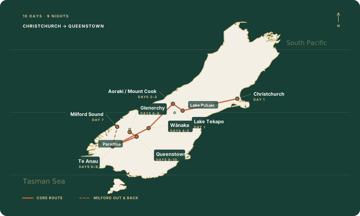

Milford is an out-and-back from Te Anau; use the official road source below for current conditions and navigation.
The route idea
This route chooses a clean mountain spine instead of collecting regions. The West Coast and Abel Tasman stay out; Dunedin and Kaikoura appear only as extensions.
Emma traveled New Zealand in December 2025. This itinerary is informed by that trip — then edited with hindsight, not reproduced drive-for-drive.
Ten days / nine nights
Christchurch → Lake Tekapo
Lake Pukaki → Aoraki; Hooker planning
Choose Hooker, Sealy Tarns or Mueller Hut
Aoraki / Mount Cook → Wānaka
Choose Roys Peak or Rob Roy Glacier
Wānaka → Te Anau
Milford Road + Milford Sound
Te Anau → Glenorchy
Paradise or partial Routeburn → Queenstown
Deer Park Heights; depart or stay
Base strategy
Two nights each at Mount Cook, Wānaka and Te Anau — your buffer for the three biggest calls: mountain weather, which hike, and Milford Road.
1
Tekapo
2
Mount Cook
2
Wānaka
2
Te Anau
1
Glenorchy
1
Queenstown
Lock the overnight bases first, then fill in the rest. Tekapo and Wānaka cover the mountain days; Te Anau is the one I’d protect if Milford matters to you.
Queenstown
For the final mountain days, Glenorchy and a more flexible finish
Find stays in Queenstown →
Some booking links are affiliate links, which means I may earn a commission at no extra cost to you.
Day 1
·
Drive · about 3 hr
·
Sleep · Tekapo
Get out of Christchurch with enough daylight to spare. Tekapo is the gentle start — walk the lakefront, check the mountain weather, turn in early. Aoraki can wait until morning.

Keep day one simple. If stargazing matters, check the operator schedule and moon phase before you book.
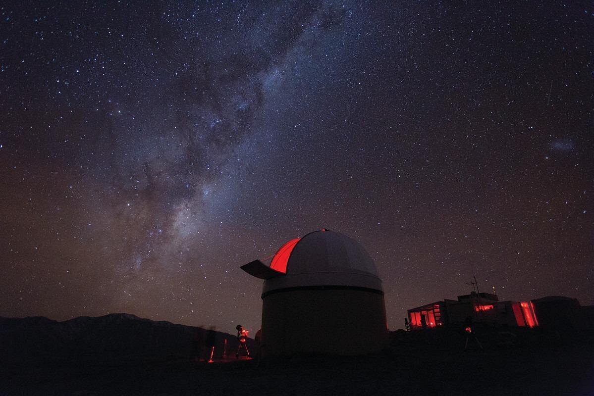
Mt. John Observatory Stargazing
On a clear night the sky over Tekapo does something no photo prepares you for. Book ahead — it sells out.
See the stargazing tour →
Check hotels in Lake Tekapo →
Day 2
·
Lake Pukaki
·
Sleep · Mount Cook
The Aoraki approach
Stop at Lake Pukaki on the way in, then keep going to the village. If weather, parking, or light looks off, skip the hike — tomorrow is the mountain day.
APPROACH
Tekapo → Lake Pukaki → Aoraki / Mount Cook. The main road is part of the day, not dead time.
USE THE AFTERNOON
Check the forecast, confirm tomorrow’s trail choice, and walk only if conditions and energy make sense.
DO NOT FORCE
A full Hooker Valley walk late in the day simply because it is possible.
Mount Cook Road
Pick one Lake Pukaki stop, then follow SH80 from open water all the way to Aoraki.
The Mount Cook Road toward Aoraki — our own photo, December 2025.
Day 3
·
Choose one
·
Sleep · Mount Cook
Don’t try to do all three. Check conditions, pick one, and leave yourself enough daylight for it.
01 / HOOKER VALLEY
TIME · 3 hr return · about 10 km
EFFORT · Mostly gentle
TERRAIN · Gravel track, suspension bridges and steps
EXPOSURE · Fast-changing alpine weather; busy trailhead
No track booking. Paid parking applies at White Horse Hill.
Best scenic return for the least climbing.
02 / SEALY TARNS
TIME · About 4 hr return
EFFORT · 600 m climb · 2,200 steps
TERRAIN · Sustained steep staircase
EXPOSURE · No shelter; snow and ice can change the walk
No track booking. Shares the White Horse Hill start.
Best when you want a hard climb without committing to the hut.
03 / MUELLER HUT
TIME · About 7 hr return to the hut
EFFORT · About 1,000 m ascent
TERRAIN · Steep steps, scree and exposed alpine route
EXPOSURE · Highest weather exposure; route skills may be required
No hut booking for a day return; book the hut if staying overnight.
Best for experienced hikers with a stable forecast and a full day.

Trail context
Terrain context only—not a current-access guarantee. Check the live DOC route before continuing beyond Sealy.
Planning note · checked September 2026. Re-check DOC before travel; alpine access and conditions can change quickly.

Tasman Glacier Heli-Hike
The splurge answer for your one mountain day — helicopter onto the Tasman Glacier, crampons on. Not cheap. Unforgettable.
See the heli-hike →
Day 4
·
Drive · about 2 hr 30
·
Sleep · Wānaka
Leave the day loose for road stops and an unhurried arrival. Wānaka doesn’t need a big plan tonight — tomorrow is the hiking decision.

Day 5
·
Choose Roys or Rob Roy
·
Sleep · Wānaka
Roys Peak is the high panorama; Rob Roy is the journey as much as the walk. Pick one — let trailhead access and weather decide.

Roys Peak
A sustained, exposed climb with no shade or water on the track. DOC lists 16 km and 5–6 hours; the elevation gain is more than 1,200 m. The trail closes annually for lambing from 1 October to 10 November.

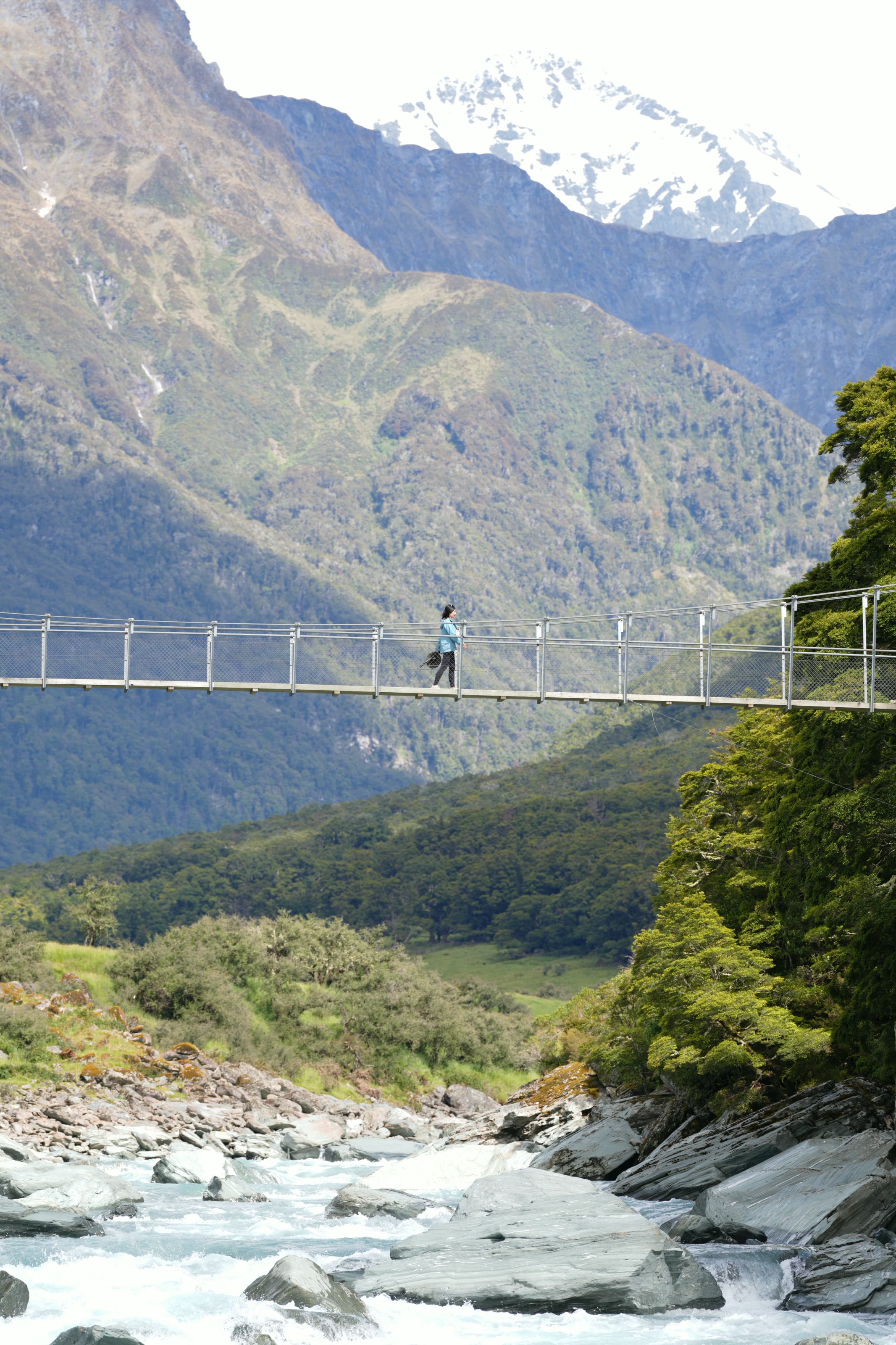
Rob Roy Glacier Track
The 10 km walk takes roughly 4–5 hours, but the remote drive matters. The last 30 km are unsealed and the final creek fords can become impassable after rain. From May to November, DOC strongly recommends stopping at the lower lookout because of avalanche risk.

At the upper viewpoint, waterfalls drop straight off the glacier. No photo conveys the scale.
Planning note · checked September 2026. Re-check DOC road, ford, closure and avalanche guidance before leaving Wānaka.
Check hotels in Wanaka →
Day 6
·
Drive · about 3 hr 30
·
Sleep · Te Anau
Strategic base
Te Anau gets two nights so Milford doesn’t become a grind. Arrive, sort the cruise details, and turn in early.
Fuel up, collect cruise details and check SH94. Keep the evening quiet.

If your Te Anau evening is free, this fills it — no extra long drive required.
See the Te Anau glow worm tour →
Check hotels in Te Anau →
Day 7
·
Road → arrival → cruise → detail
·
Sleep · Te Anau
The 119 km Milford Road needs at least two hours without stops. In practice, allow more: viewpoints, one-lane traffic and a 30-minute park-and-walk or shuttle margin before cruise check-in.

01 · ROAD — Leave Te Anau with time for the stops that make Milford Road more than a transfer. Check current conditions before setting out.

02 · ARRIVAL — The first wide view of Milford Sound is quieter than the cruise to come: dark walls, open water and a boat heading into the fjord.

03 / Cruise
Choose the cruise time around the drive you want to have, not the other way around. There is no reliable mobile coverage along the road, so save booking details and directions offline.

04 · DETAIL — This kea appeared beside the road on our December 2025 drive. Treat any wildlife encounter as luck, not part of the itinerary.
Planning note · checked September 2026. Live road, weather and operator status always outrank this itinerary.

If Milford is the reason you’re here, book this first. Cruise-only fits the self-drive plan — no bus, no package.
See Milford Sound cruise options →
Day 8
·
About 2 hr 45 before stops
·
Sleep · Glenorchy
That 2 hr 45 comes from official Te Anau–Queenstown and Queenstown–Glenorchy drive times. Add margin for fuel, the road itself, and the stops you’ll actually want.

Day 9
·
Choose one branch
·
Sleep · Queenstown

Option A / Paradise
Spend the morning in the valley itself. The red shed, the open ground, the small human details — it feels like a place people live, not a viewpoint.
Option B / Partial Routeburn
From Routeburn Shelter, Routeburn Flats Hut is 7.5 km and roughly 1.5–2.5 hours one way. A day walk does not require a hut booking; overnight Great Walk stays do. Turn around early enough to reach Queenstown without making the evening another endurance event.

Planning note · checked September 2026. Great Walk hut bookings and seasonal conditions change; consult DOC for the version of the trip you will actually take.

Want the Glenorchy and Paradise scenery without driving it all yourself? This is the one.
See the Glenorchy tour →

Shotover Jet
The classic Queenstown adrenaline hit — 25 minutes through narrow canyons. Do it your first afternoon in town.
See the Shotover Jet →
Check hotels in Queenstown →
Day 10
·
Deer Park Heights
·
Departure or final night
Skip the generic city finale — finish above Queenstown instead. Deer Park Heights is a working farm with prebooked vehicle access; confirm current entry rules before going.
Leave the final morning loose. A slow last look over the basin beats one more rushed stop before the airport.
Planning note · checked September 2026. Re-check Deer Park’s official visitor information and booking rules before travel.

TSS Earnslaw & Walter Peak BBQ Lunch
The slow alternative — steam across Lake Wakatipu on a 1912 steamship, lunch at Walter Peak station.
See the Earnslaw cruise →
Planning note · checked September 2026
Book in the order things sell out. Keep live conditions out of the static plan and re-check them close to departure.
01 / NIGHTS
Secure Mount Cook first, then Te Anau, Wānaka, Glenorchy and the end points. The two-night bases are the route’s weather buffer.
02 / MILFORD
Choose a cruise that leaves a realistic road margin. Save confirmation details offline and check SH94 live status on the day.
03 / HIKES
Don’t marry a hard hike to one weather forecast. Carry a gentler backup for Aoraki and Wānaka.
04 / ROUTEBURN
Book a hut only if you are actually staying overnight. For a day walk, plan the turnaround around the Queenstown drive.
If you have 9 days
Keep the two nights at Mount Cook, Wānaka and Te Anau. Remove the Glenorchy overnight and travel Te Anau → Queenstown on Day 8; use Day 9 for a Queenstown-side choice. Don’t squeeze Milford into the Wānaka transfer day.
If you have 12 days
Dunedin and Kaikoura aren’t missing pieces — they’re separate trips. Attach one when wildlife or the east coast matters more than keeping the mountain line tight.

Dunedin / Otago Peninsula
Best for travelers who’ll commit to a guided evening wildlife tour and don’t mind the extra east-coast driving. Don’t wedge it into the ten-day mountain route.


Kaikoura
Best for travelers who can add the east-coast leg without giving up a mountain day. Treat it as a deliberate extension, not a Christchurch day trip squeezed between long drives.


WHAT’S INSIDE
01
Trail access, parking and realistic time commitments for the major hiking choices.
02
Routeburn, Milford, Kepler and Abel Tasman—when they are worth restructuring a trip around.
03
What to do when the mountain day you planned no longer makes sense.
04
Original planning maps, trailhead and access guidance, and links back to current official sources.


65-page print/tablet guide + a separate 125-screen mobile field edition
Get the South Island Field Guide · $5.99
Both editions are included