GUIDES
/
Washington State
Washington State Fall Colors 2026: Best Places, Timing & Hikes

GUIDE TYPE
Seasonal Guide
RECOMMENDED DAYS
1–3 days
BEST SEASON
September–October, weather dependent
LAST VERIFIED
RIGHT NOW
White River Road reopened September 5. Sunrise Road remains closed to public vehicles; check current NPS conditions for trail and fire closures.
TYPICAL WINDOWS · NOT 2026 GUARANTEES
GEOGRAPHIC ORIENTATION
Seattle and Bainbridge sit together in Puget Sound. Rainier, Mt. Baker and the North Cascades are three different mountain corridors; treat each as its own day rather than forcing a statewide checklist.


Orientation only—not a driving map. Check live roads, ferry status and trail access before departure.
MOUNTAIN CHAPTER 01
Mount Rainier Fall Colors: Red + Rust Beneath the Mountain
Rainier is the most cinematic first choice when the mountain is visible: subalpine huckleberry and mountain ash layer color beneath glaciers, with real options from a short Paradise walk to a full Skyline day.
Emma’s pick · Best first mountain trip when Paradise access and visibility are good


Paradise at Mount Rainier — red and rust subalpine color usually builds from mid-September into early October, with timing varying by year and weather.
TRAIL DECISIONS
Skyline Trail / Paradise
A major Rainier day with continuous subalpine scenery.
5.5 MI
+1,700 FT
~4.5 HR
STRENUOUS
FALL COLOR · Red, rust and yellow shrubs beneath glaciers
ACCESS · Paradise / Jackson Visitor Center
Naches Peak Loop
A contained loop with meadows, lakes and a classic Rainier reveal.
3.5 MI
+500 FT
~2 HR
EASY
FALL COLOR · Shrubs and meadow color
ACCESS · Tipsoo Lake / SR 410
Nisqually Vista
A lower-effort Paradise option with glacier views when clear.
1.2 MI
~45 MIN
EASY
FALL COLOR · Meadow color beneath Rainier
ACCESS · Lower Paradise parking area
WHAT CAN CHANGE THE PLAN
Road and fire closures can separate one park corridor from another, while cloud can remove the view you came for. Check the exact entrance and trail—not just the park name.
MOUNTAIN CHAPTER 02
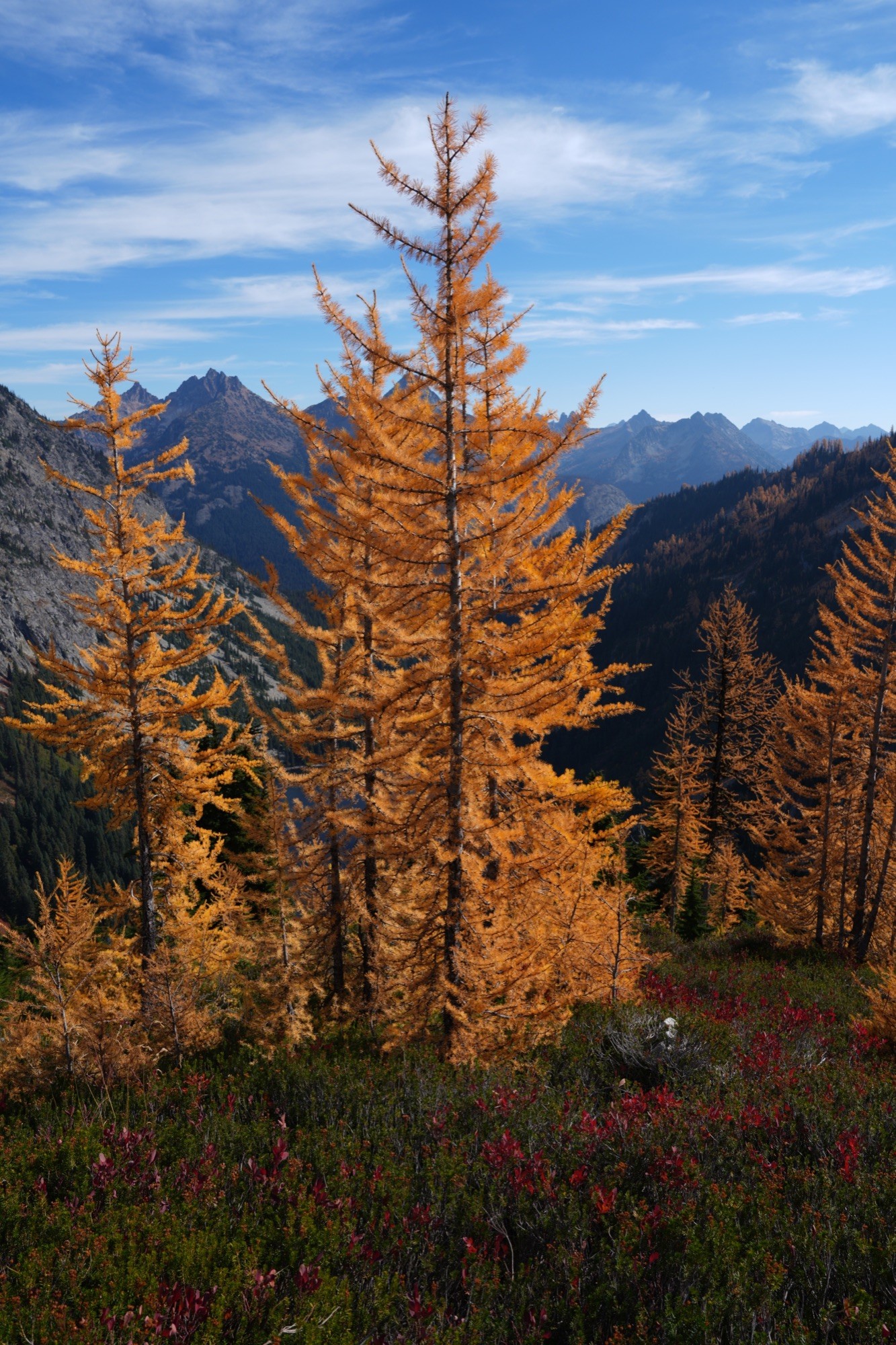
Choose the North Cascades when larches are the point of the trip and you are comfortable making the day about the hike. The reward is the clearest gold-on-granite fall story in the state.
Emma’s pick · Best for larches and a hiking-first day


TRAIL DECISIONS
Heather–Maple Pass
The primary larch objective with broad alpine-basin scenery.
SEE OFFICIAL SOURCE
FALL COLOR · Golden larches and alpine basins
ACCESS · Rainy Pass / SR 20
Blue Lake
A more contained lake-and-larch hike along the SR 20 corridor.
SEE OFFICIAL SOURCE
FALL COLOR · Larches, granite and blue water
ACCESS · Blue Lake trailhead / SR 20
Cascade Pass / Sahale
Cascade Pass is the contained objective; Sahale is a separate, much harder extension.
3.7 MI ONE WAY
+1,700 FT
MODERATE
FALL COLOR · Meadows and high-alpine terrain
ACCESS · Cascade River Road
WHAT CAN CHANGE THE PLAN
Fire, smoke and early snow can change both the view and the practicality of the drive. Verify the exact trail, SR 20 and air quality before leaving Seattle.
MOUNTAIN CHAPTER 03
Heather Meadows is the flexible mountain chapter: short high-payoff viewpoints when visibility is brief, plus Chain Lakes when the weather and access support a fuller hiking day.
Emma’s pick · Best mountain backup when you want scalable effort


TRAIL DECISIONS
Chain Lakes Loop
A fuller Heather Meadows day with lakes and mountain architecture.
SEE OFFICIAL SOURCE
FALL COLOR · Heather, berry shrubs and alpine lakes
ACCESS · Heather Meadows / SR 542
Artist Ridge
Short, high-payoff scenery when the final Artist Point road is open.
100-YD PAVED OVERLOOK
SEE OFFICIAL SOURCE
FALL COLOR · Alpine foliage beneath Baker and Shuksan
ACCESS · Artist Point / end of SR 542
Bagley Lakes / Heather Meadows
A lower-commitment scenic option below Artist Point.
SEE OFFICIAL SOURCE
FALL COLOR · Meadows, water and alpine foliage
ACCESS · Heather Meadows / SR 542
WHAT CAN CHANGE THE PLAN
The final upper road and cloud ceiling matter as much as color. If the mountains disappear, do not force a long loop for scenery that is not there.
LOW-EFFORT · WEATHER-FLEXIBLE
These lowland options extend the season and save a poor mountain-visibility day. Keep them condensed: choose Seattle for easy garden variety or Bainbridge for a ferry-led day with woodland and waterfront.

FERRY DAY · GARDENS · FOREST · WATERFRONT
Bainbridge Island
Choose Bainbridge when the ferry is part of the day: one destination garden or woodland walk, then a waterfront finish. Check live sailings rather than planning around a hard-coded ferry.
A lowland garden scene on Bainbridge Island.

Seattle Parks & Gardens
Choose Seattle when visibility is poor or effort needs to stay low. The Arboretum, Japanese Garden and Kubota Garden offer distinct color without a mountain drive.
BUILD THE TRIP
A strong Washington fall trip has a primary corridor and a backup that still feels worthwhile. More days create flexibility; they should not create pressure to collect every region.
ONE DAY
Choose one primary region and one realistic backup.
TWO DAYS
Use one mountain day and keep the second day flexible.
THREE DAYS
Combine a mountain objective, a second region or lowland fallback, and one flexible day.
MOUNT RAINIER
Best for Paradise access
Best base for Paradise and southwest-side Rainier plans.
Check nearby stays and availability.
See hotels in Ashford
NORTH CASCADES
Best for larch trips
A practical base for an SR 20 and larch-focused North Cascades trip.
Compare stays for your larch base.
See hotels in Winthrop
MT. BAKER
Best for Mt. Baker flexibility
More lodging and dining flexibility before heading toward Heather Meadows and Artist Point.
Browse lodging with more flexibility.
See hotels in Bellingham
MOUNT RAINIER
No-driving option
For Seattle-based travelers who prefer a guided Rainier day without driving.
Open tour details and current pricing.
See Rainier tour
SNOQUALMIE + SEATTLE
Easy scenic day
A lower-effort scenery option when you do not want a full mountain hiking day.
Review the route, timing and pricing.
See Snoqualmie tour
LEAVENWORTH
Fall-town day trip
A scenic alternative combining mountain-country views with time in Leavenworth.
See tour details, timing and pricing.
See Leavenworth tour


FIELD GUIDE PREVIEW
DIGITAL PRODUCT
TRAIL DECISIONS
Compare effort, color and access quickly.
CONDITIONS LOGIC
Know when weather, snow, smoke or roads should change the plan.
BACKUP PLANS
Same-region and city or lowland alternatives.
1–3 DAY ROUTES
Build a flexible itinerary without forcing bad conditions.
Includes parking strategy, official condition links, Seattle and Bainbridge fallbacks, and printable planning pages.
FREE GUIDE · Where to go, typical timing and official checks
FIELD GUIDE · Trail comparisons, backup plans and flexible 1–3 day routes
Get the Field Guide — $5.99
Mobile + print editions included · One-time purchase
FINAL CHECKS
Foliage timing is only one input. Recheck access, fire, smoke, weather and ferry information close to departure; each source below answers a different failure point.
North Cascades fire closures
Active incidents, trail closures and smoke context.
Washington State Ferries
Live schedules, service alerts and terminal information.